An RTK drone writes the height above the ellipsoid into every photo. Plans, ground control and design levels use height above sea level. Converting the photos first means the model comes out at the levels everyone else uses.
Convert a flight
- Open the Height Datum Converter.
- Drop in the photos from the flight, or choose the folder.
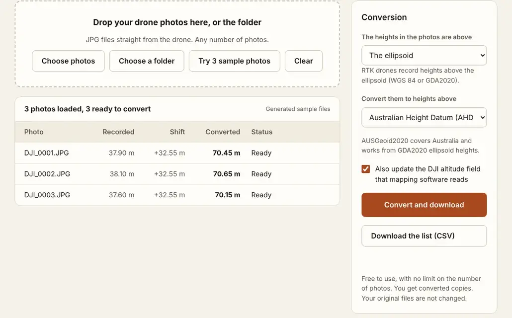
- Under The heights in the photos are above, leave The ellipsoid.
- Under Convert them to heights above, choose the sea-level surface your project uses.
- Check the table. It shows the recorded value, the shift and the converted value for each photo.
- Select Convert and download. You get converted copies. Your original files are not changed.
The photos stay on your device. Only the height model data for the area is loaded, from this site.
Which surface to choose
| Your project uses | Choose |
|---|---|
| Australian Height Datum (AHD) | Australian Height Datum (AHD) |
| Sea level, with no national datum named | Sea level, EGM2008 |
| Software or a client that asks for EGM96 | Sea level, EGM96 |
If you are not sure, ask whoever supplied the ground control or the design levels which datum they are in. The two kinds of value are explained in Ellipsoid vs Orthometric Height Explained.
What the shift looks like
The shift is the gap between the ellipsoid and sea level at the photo's position. In Perth it is about 32.5 metres: a photo recorded at 20.00 m above the ellipsoid becomes 52.53 m above AHD.
The tool looks the shift up for every photo separately. Across a small site it changes by millimetres. Across several kilometres it can change by a few centimetres.
Or give the software a list
Some mapping software takes photo positions from a text file instead of from the photos. Select Download the list (CSV) to get the file name, latitude, longitude and both values for every photo.
When this is the wrong tool
If the drone has no RTK, its recorded altitude comes from air pressure and can be tens of metres out for other reasons. Use the Drone Altitude Fixer for those photos.
Questions
Does it change the position of the photos?
No. Latitude and longitude stay as they are. Only the vertical value is rewritten.
Can I convert back?
Yes. Swap the two surfaces and run the converted copies through again.
My model is still at the wrong level. Why?
See Why Is My Drone Map at the Wrong Height? for the other causes.
Does mapping software do this itself?
Some can, if you set the vertical datum of the photos and of the output correctly. Pix4D's guidance recommends converting with a precise local geoid model before import.