An RTK drone records how good its position was for every photo. Before you process the flight, check that the photos are RTK fixed, that their accuracy is what you expect, and that every photo has its line in the .MRK file. It takes a minute and saves a reprocess, or a return trip to the site.
Check the flight
- Copy the flight folder from the memory card. It holds the JPG photos and a file ending in Timestamp.MRK.
- Open RTK Photo Check.
- Drop the whole folder onto the page, or choose the photos and the .MRK file.
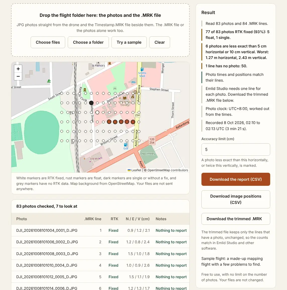
- Read the result on the right: how many photos are fixed, the worst accuracy, and any photo or line that does not match.
- Look at the map. Rust and dark markers are the photos to check.
- Download the report, and the image positions with their accuracy if your software needs them.
Only the start of each photo is read, on your own device. Nothing is uploaded.
What to look for
| Result | What it means |
|---|---|
| Fixed | Full RTK correction, usually 1 to 3 cm. Ready to process. |
| Float | Partial correction, often 10 to 50 cm. Usable with a looser accuracy, or after PPK. |
| Single | No correction: an ordinary GPS position, a metre or more out. |
| No line, or no photo | The photos and the .MRK file do not match one for one. |
| Time or position differs | The photo was paired with the wrong line, usually after a rename or a mix of folders. |
DJI advises against using photos that are not fixed directly for mapping. A few float photos at the start of a flight, while the drone settles, are common. A long run of float or single photos in the middle usually means the correction signal dropped out, from a weak mobile connection or a base station out of range.
What is in a DJI .MRK file explains each value the tool reads.
When some photos are not fixed
- Few photos, spread out: keep them. Give your processing software each photo's own accuracy, so it trusts them less. The image positions download does this.
- A long run: correct the flight with PPK, from the drone's raw satellite data and a base station, in software such as Emlid Studio. Then check the result again.
- Ground control points on the site: they hold the model in place even where the photo positions are weak.
If the counts do not match, photos that do not match the .MRK file covers the causes and the fix. For gaps, overlap and blurred photos in the same flight, see how to check drone photos before processing.
Questions
Do I need the .MRK file?
No, for a first look. DJI RTK drones such as the Phantom 4 RTK write the RTK status and accuracy into each photo as well. The .MRK file adds the match between photos and lines, and the time of each photo.
What accuracy limit should I use?
5 cm horizontal suits most mapping. The vertical limit is twice the horizontal one, because RTK heights are about half as exact as positions. Lower it for survey work.
Are the heights above sea level?
No. RTK heights are above the ellipsoid. Convert them before comparing with heights on a plan. Ellipsoid and orthometric height explains the difference.
Does the check change my files?
No. The photos and the .MRK file are read and left as they are. The downloads are new files.