A mapping job fails late. The missing photo, the thin overlap or the blurred line shows up hours into processing, when the site is far away. A check straight after the flight finds the same problems in a few minutes.
Check a flight
- Copy the photos from the drone's card to a computer.
- Open the Drone Flight Check.
- Drop in the photos from one flight, or choose the folder.
- Read the result. Each line is one check.
- Look at the map. Filled markers are the photos to look at, and each rectangle is the ground one photo covers.
- Press "Check sharpness and exposure" to have every picture read.
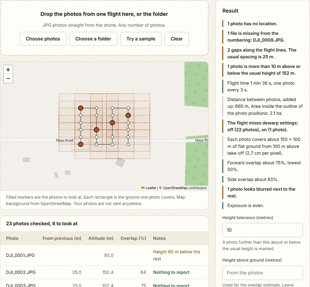
The photos stay on your device. Only the map background is loaded from the internet, so the check itself works with a poor connection once the page is open.
What the check looks at
| Check | What it tells you |
|---|---|
| Location | Photos with no GPS position. Mapping software cannot place them. |
| Numbering | Files missing from the drone's numbering, by name. |
| Spacing | A step along a flight line much longer than the usual spacing. |
| Height | Photos well above or below the height of the rest. |
| Time | The flight time, and any long break, such as a battery change. |
| Camera settings | A flight that mixes cameras, lenses, picture sizes or the DJI dewarp setting. |
| Overlap | The ground each photo covers, and an estimate of forward and side overlap. |
| Sharpness and exposure | Photos that are blurred, or much darker or brighter than the photos around them. |
What to do with the result
Missing files. Look on the card first. A file that was not copied is the common case. If it is not on the card, the drone did not save it. Why Are Photos Missing from My Drone Flight? lists the causes.
Gaps and low overlap. One missing photo in a line with high overlap is usually covered by its neighbours. Two or more in a row, a gap at the edge of the site, or overlap below what your software asks for is worth flying again while you are still there.
Height. Photos taken during take-off, landing or a test shot sit well below the rest. Leave them out of processing.
No location. Leave these photos out, or add a position with the Batch Geotag Photos tool if you have a track.
Mixed camera settings. Process the two sets as separate camera groups, or fly again with one setting. Dewarp is the usual one: it changes the lens distortion in the picture, so photos with it on and off do not fit one camera model.
Blurred, dark or bright photos. Open a marked photo and look at it. One blurred photo among sharp neighbours can be left out. A run of them means the shutter was too slow for the speed, and that part is worth flying again.
How the overlap estimate works
The tool reads the lens and the picture size from each photo, and the height above the take-off point that DJI drones record. From those it works out the ground one photo covers. It compares that with the distance to the next photo and to the next flight line.
It assumes flat ground and a camera pointing straight down. Over a hill the real overlap is lower than the estimate, because the ground is closer to the camera. If the site is higher or lower than the take-off point, type the height above ground yourself.
Keep a record
Download the report. It is a CSV file with one line for each photo: position, date, spacing, footprint, overlap and any notes. It is useful when a client asks what was flown.
Questions
How much overlap is enough?
Most mapping software asks for about 75% forward and 60% side overlap. See How Much Overlap Do Drone Mapping Photos Need?
Why does the step between two flight lines not count as a gap?
It is longer by design. The tool only marks a long step that runs along a line.
How long does the sharpness check take?
Count on a few minutes for a thousand photos on a laptop, because each picture is opened in full. The other checks read only the start of each file and finish in seconds.
The altitude in my photos looks wrong. Does that matter here?
Not for this check, which compares photos with each other and uses the height above take-off. For mapping it does matter: see Why Is the Altitude Wrong in My DJI Photos?.