A point cloud that lands in the wrong place, or that GIS software will not place at all, usually has a missing or wrong coordinate system record. First find out which system the numbers are really in. If they are right and only the record is missing, write the record into the file. If they are in the wrong system, convert every point.
Check the file first
- Open the LAS and LAZ Check.
- Drop the LAS or LAZ file onto the page. It is read on your device and not uploaded.
- Read the report. It says what the file states about its coordinate system, and whether the coordinates fit that system.
Missing: set the system
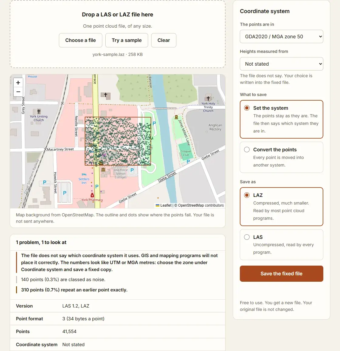
Drone mapping software often writes the right coordinates but no record of the system. The numbers then look like this: eastings from 100,000 to 900,000 and northings in the millions, which is UTM or MGA in metres. What the numbers cannot tell you is the zone or the datum. Take those from the project: the settings of the processing software, the base station, or the survey brief.
- Under "The points are in", choose the system, for example GDA2020 / MGA zone 50.
- Under "Heights measured from", choose the height system, or leave it as not stated if you do not know.
- Check the outline on the map. If it sits over the right place, the choice is right.
- Keep "Set the system" and press "Save the fixed file".
The points are not touched. The new file only says which system they are in.
Wrong: convert the points
Convert when the points are in a different system from the one you need, for example a survey in GDA94 for a project in GDA2020, or heights above the ellipsoid for plans that use AHD.
- Set "The points are in" to the system the file is in now.
- Choose "Convert the points", then the system and the heights to convert to.
- Press "Save the fixed file".
Converting a point cloud from GDA94 to GDA2020 explains that change, and ellipsoid and orthometric height explains the heights.
How to tell which is which
| What you see | Likely cause | Fix |
|---|---|---|
| The file will not show on a map at all | No coordinate system record | Set the system |
| It is in the right area but 1.5 to 1.8 m out | GDA94 and GDA2020 mixed up | Convert |
| It is hundreds of kilometres away | Wrong zone | Set the right zone |
| It is tens of metres too high or too low | Ellipsoid heights against AHD | Convert the heights |
Questions
Does setting the system change my points?
No. Only the record that names the system is written. Every point keeps its numbers, so the file can be set again if the first choice was wrong.
Which record does the file get?
A LAS 1.4 file gets the system as WKT text, which LAS 1.4 requires. LAS 1.0 to 1.3 files get GeoTIFF keys, which older software reads. Any old record is replaced.
Can I save LAZ from a LAS file?
Yes. Choose LAZ under "Save as". LAZ is the same points, packed smaller. LAS and LAZ explains the difference.
What if my system is not in the list?
The tool covers WGS 84, GDA94 and GDA2020 in degrees, every MGA zone and every WGS 84 UTM zone. For a state grid or a local site grid, use PDAL or desktop GIS software.