If the altitude in your DJI photos is wrong, correct it before you process the flight. You can do it inside your mapping software, or you can correct the photos themselves so they are right wherever you load them.
Correct the photos
- Find the ground height at your take-off point, in the height system your project uses.
- Open the Drone Altitude Fixer and drop in the photos from the flight.
- Check the table. It shows the altitude recorded in each photo and its height above take-off.
- Choose "Set the ground height at take-off" and enter the ground height. Each photo gets ground height plus its own height above take-off.
- Keep "Also update the DJI altitude field that mapping software reads" ticked.
- Select "Correct and download". You get corrected copies. Your original files are not changed.
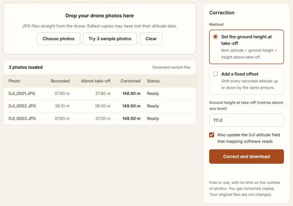
The tool works in your browser. Your photos are processed on your own device and are not uploaded. It is free to use, with no limit on the number of photos.
Which method to choose in the tool
| Method | Use it when | What each photo gets |
|---|---|---|
| Set the ground height at take-off | You know the true height of the take-off point | Ground height + that photo's height above take-off |
| Add a fixed offset | You know how far out the recorded altitude is | Recorded altitude + the offset |
The first method keeps the height differences between photos, so it also suits flights that climbed or followed terrain.
Or correct it inside the mapping software
PIX4Dmapper. Pix4D's advice is to fix the altitudes by hand before the first processing step. In the Image Properties Editor, right-click a cell in the altitude column, choose Edit All Altitudes and enter the new value. This gives every photo the same altitude, so Pix4D notes it works best when the flight height stayed fairly constant.
Agisoft Metashape Professional. Agisoft publishes two scripts. One reads the height above take-off from each photo. The other adds an offset you enter to every camera. You need the height of the take-off point to use them.
Both work. Both correct the project, not the photos. Load the same photos into other software and the wrong altitude is back.
Why the second altitude field matters
A DJI photo holds its altitude in more than one place. Pix4D staff state that for DJI drones PIX4Dmapper reads the DJI field, not the standard one. If you correct only the standard field, that software still sees the old value. The Drone Altitude Fixer corrects both. See DJI Altitude Fields Explained.
What this does not do
- It does not replace ground control points or RTK. It puts the flight at about the right height. It does not make a survey-grade result.
- It works on JPG photos that already hold an altitude. It does not read DNG raw files.
- The result is only as good as the ground height you enter.
Questions
How do I check the result?
Open one corrected photo in the Photo GPS Extractor. The altitude shown should match ground height plus flight height.
Does it change the picture?
No. Only the altitude values are rewritten. The image itself is left as it is.
How do I know my photos need fixing?
See Why Is the Altitude Wrong in My DJI Photos?
Sources
- Mavic 2 Pro Incorrect Altitude, Pix4D community, July 2019
- Correct altitude in image metadata, incorrectly read by Pix4D Mapper, Pix4D community, 2020
- Working with DJI photos altitude problem, Agisoft, last changed February 2026